
Imagine driving a vehicle on a dirt track that climbs higher than Everest Base Camp. The thin mountain air contains only half the oxygen available at sea level. Outside your window, the massive gravel landscape looks like the surface of another planet. Welcome to Mig La Pass Ladakh, the new highest motorable road in the world located in Ladakh, India. This remote border route is quickly becoming the ultimate road trip destination for adventure drivers. This comprehensive resource outlines the critical road conditions, route maps, travel difficulty, inner line permissions, and medical safety tips essential for a successful high-altitude driving journey.
You will not find luxury hotels or paved tour bus routes out here. The journey tests your vehicle and your mental focus with every single mile. Your engine loses power in the thin air while your tires fight for grip on loose rocks. It is a tough, lonely drive through the wilderness, but the view from the top is worth the struggle.
Mig La Pass: World’s Highest Motorable Road in Ladakh
If you love road trips, you need to know about this new route. Indian military engineers recently finished building a historic new mountain road in Eastern Ladakh. Officially called the Likaru–Mig La–Fukche Road, this 64-kilometer path goes right through the quiet and remote Changthang region. Mig La Pass sits right in the middle of this highway. At 19,400 feet above sea level, it is now officially the highest drivable road in the world. While the road connects the towns of Likaru and Fukche, normal tourists are currently only allowed to drive up to the top of the pass and head back.
The Engineering Challenges Behind the Mig La Pass
Building a paved road at 19,400 feet is incredibly difficult. To complete this high-altitude project, the Border Roads Organisation (BRO) had to face four major natural problems:
- Low Oxygen: There is 50% less oxygen at the top than at sea level. This made workers get sick easily and feel completely exhausted just by standing still.
- Extreme Cold: Temperatures dropped to -30°C. Water froze instantly, so workers needed special heating equipment just to mix the concrete properly.
- Engine Problems: Just like people, car engines need oxygen to run. Vehicles lost a lot of power in the thin air, and their fluids froze solid inside the engines.
- Frozen Ground: The soil here stays frozen all year long. Workers could not dig through the dirt normally and had to blast through ground that was as hard as concrete.
The New Destination for Travelers
This new road changes the map for adventure travelers, giving them a brand-new place to explore away from the usual crowded tourist spots. For a long time, driving up Khardung La was the ultimate goal for travelers. Later, Umling La became the highest spot. Now, Mig La Pass has taken the lead as the highest drivable point on Earth.
Top 5 Highest Motorable Roads in the World.
| Rank | Mountain Pass / Road | Location | Elevation (Feet) |
|---|---|---|---|
| 1 | Mig La Pass | Ladakh, India | 19,400 ft |
| 2 | Umling La | Ladakh, India | 19,024 ft |
| 3 | Uturuncu | Potosí, Bolivia | 18,930 ft |
| 4 | Dungri La (Mana Pass) | Uttarakhand, India | 18,406 ft |
| 5 | Khardung La | Ladakh, India | 17,582 ft |
How to Reach Mig La Pass from Leh
Planning a drive from Leh to Mig La Pass ladakh means prepping for one of the most remote overland journeys in Ladakh. The final ascent kicks off at Likaru Village, which sits between 240 and 270 kilometers from Leh depending on your route. Because this region edges right up against the sensitive eastern frontier, you need to think less about continuous driving hours and more about how your body handles rapid elevation changes before hitting the gateway to the pass.
Choosing Your Path Through the Mountains.
Before you can tackle the final giant climb to the summit, you must navigate your way across the open plains and high passes of eastern Ladakh. There are three distinct routes out of Leh, each offering a completely different visual experience, unique road conditions, and its own set of challenges for the modern adventure traveler
First Route: The Direct Highway (Via Chumathang)
- Route: Leh ➜ Karu ➜ Upshi ➜ Chumathang ➜ Nyoma ➜ Loma Bend ➜ Likaru (225 km).
- Pros & Cons: This is the fastest, safest, and smoothest route along the Indus River valley. It offers the best tarmac, which saves your vehicle from heavy wear and tear. On the downside, the scenery is less dramatic and more predictable compared to the high lake circuits.Best.
- Overnight Stop:Chumathang (13,000 ft) is the ideal town to break your journey on this track.
Second Route : The Scenic Lake Route (Via Pangong Tso & Chushul)
- Route: Leh➜ Chang La Pass ➜ Tangtse ➜ Pangong Tso ➜ Man ➜ Merak ➜ Chushul ➜ Rezang La Memorial ➜ Tsaga La ➜ Loma Bend ➜ Likaru (310 km).
- Pros & Cons:This route gives you jaw-dropping views as you drive right alongside the brilliant blue waters of Pangong Lake and the remote Indo-China border. However, the threat here is real—you will face rough, bumpy dirt and gravel tracks, and you must secure specialized military permit clearances for the Chushul-Tsaga stretch.
- Overnight Stop:Tangtse (12,800 ft) is the best, most sheltered village for a safe night’s sleep. It is highly recommended to stay here because sleeping directly at Pangong Lake (13,940 ft), where the biting cold winds howl all night, can severely worsen altitude sickness.
Third Route : The High-Altitude Plain Route (Via Tso Moriri).
- Route: Leh➜ Tanglang La Pass ➜ Debring ➜ Tso Kar Lake ➜ Puga Hot Springs ➜ Mahe Bridge ➜ Nyoma ➜ Loma Bend ➜ Likaru (325 km).
- Pros & Cons:A dream route for seeing Ladakh’s wild side, taking you past vast saltwater plains, bubbling hot springs, and rare high-altitude wetlands. The major danger is the relentless, sustained elevation of the plains, which can quickly trigger mountain sickness if you haven’t given your body proper time to adapt.
- Best Overnight Stop: Karzok (15,000 ft) near Tso Moriri is the main hub for an overnight stay.
The Reality of Altitude Sickness on the Route.
Let’s look at the numbers: Leh rests at 11,480 feet, but Mig La Pass ladakh tops out at a massive 19,400 feet Driving this entire stretch in a single day forces an overnight altitude jump of nearly 8,000 feet. At the summit, the atmospheric pressure drops significantly, effectively cutting the available oxygen molecules in half compared to sea level.
Pushing through this transition without stopping creates a major health hazard. Acute Mountain Sickness (AMS) doesn’t give warnings; it manifests quickly as debilitating headaches, severe nausea, and in worst-case scenarios, fluid retention in the lungs (HAPE). Because the eastern frontier has virtually no civilian medical infrastructure and emergency help is hours away, military checkpoints will actively turn back any travelers showing signs of physical distress. Pacing your ascent is a strict operational requirement for this road trip.
The Final Approach to the Summit.
No matter which of the three paths you choose to cross the wilderness of Ladakh, all tracks eventually funnel into the lonely, heavily guarded Loma Checkpost. After clearing the military gates at Loma, you will drive into the open valley toward Hanle until you reach the small base village of Likaru (14,100 feet)
At Likaru, the pavement splits. You will take a sharp turn onto the official 64-kilometer Likaru–Mig La–Fukche (LMLF) Road. This is where the true climb begins. The road tilts upward, winding through a steep, dramatic 34-kilometer ascent that pushes your engine and your camera to their absolute limits before landing you at the world-record Mig La Pass summit at 19,400 feet.
Important Border Safety Note: The thin strip of road continuing past the summit down toward Fukche runs directly into a highly sensitive military zone near the international border. Civilian travelers are strictly prohibited from driving past the pass. Enjoy the incredible view from the top, snap your photos, and turn your vehicle back around immediately.
Designing Your Adventure: Two Smart Itineraries.
Option 1: The Slow Caravan (The Safest and Most Rewarding Way)
If you want to savor every sunset, explore hidden corners, and keep your body completely safe from altitude sickness, this is your route. It breaks the long drive into manageable, beautiful pieces.
- Day 1: The Gentle Warm-Up.Leave Leh behind and make your way to your first overnight oasis. If you chose the highway, soak in the natural hot springs of Chumathang. If you chose the lake route, settle into a cozy homestay in Tangtse. resting up before you hit the water the next morning.
- Day 2: Into the Starry Night. Wake up early, drive past the majestic lakes or open plains, and head deep into the frontier. You will cross the valleys and check into a local homestay in Hanle (14,760 ft), a village famous for its incredibly clear night skies and dark sky reserve.
- Day 3: Reaching the Peak. With two full nights of mountain sleep under your belt, your body is ready. Drive the short 15 km back to the Likaru junction, make the grand 34 km climb to the 19,400 ft summit of Mig La Pass, celebrate at the top, and head back down to lower ground with a camera full of memories.
Option 2: The Focused Arrow (The Direct Push)
This itinerary is built for experienced mountain travelers who are short on time but high on endurance. It cuts out the middle stops, but requires strict discipline. Only attempt this if you have already spent at least 3 to 4 full days completely resting and acclimatizing in Leh.
- Day 1: The Long Haul. Fire up your engine early and take Route 1 straight out of Leh. You will drive a solid 255 kilometers over 7 to 8 hours, passing the Likaru turnoff without stopping, and head straight to Hanle (14,760 ft) to unpack, eat a warm meal, and sleep.
- Day 2: The Summit Strike. Wake up with the sunrise, drive back down to the Likaru junction (14,100 ft), and tackle the steep, breathtaking 34 km mountain road to the top of the world at Mig La Pass before heading back toward Leh.
If you ask whether it is physically possible to climb Mig La from Leh in a single day, the answer is technically yes—but doing so ignores the basic biology of high-altitude travel. The real irony of this route is that the fastest way to successfully reach the highest drivable point on Earth is to deliberately slow down and split your journey into a two-day run. Pacing your overnights based on your chosen route gives your lungs the time they need to adapt to the thin air. It keeps your trip safe, ensures you pass the military checkpoints without medical delays, and lets you actually enjoy the view from the absolute ceiling of the motoring world.
Here is the complete section with your Flesch-score optimized conclusion integrated at the bottom:
Best Time to Visit Mig La Pass (and When it Closes)
At 19,400 feet, Mig La Pass stays frozen for most of the year. The weather is harsh. You can only drive here during a very short window when the ice clears.
June to September
This is the best time to go. It is the only safe choice for ordinary cars and bikes. By June, army workers clear all the winter snow off the blacktop. The road is dry, your tires will grip well, and local guesthouses are open. Even on sunny summer afternoons, the air at the top is freezing cold.
Mid May and October
These weeks are a big gamble. Only try this if you have a high 4×4 car and know how to drive on ice. In May, crews are still clearing heavy snow. A sudden blizzard can trap you for days. In October, the days get very short. Melting snow turns to dangerous black ice on the steep 34-kilometer climb. You must carry tire chains to get past the guard posts.
November to April
The pass is completely closed to civilians during these months. The cold drops past minus 30 degrees. Heavy storms bury the entire road under deep snow. No rescue teams or doctors work in the valley during the winter. The army post at Loma will turn back all tourist cars without exception.
July and August
The pass sits in a dry desert, so it does not rain at the top. But the summer monsoon still creates a big trap on your way back to Leh. Heavy rain on the other side of the mountains causes sudden floods and mudslides. Rocks can block the main roads and valleys. Your skies might be blue at the summit, but your road home could be washed away for days.
Go in June or September. These are the best two months for the trip. July and August have dry skies at the top of Mig La. But heavy summer rains can block the roads near Leh. Mudslides might trap you on your way back. If you manage to reach Likaru, you can easily finish the climb. Just make sure to add extra days to your plan if you travel in mid-summer.
Mig La Pass Road Conditions and Real Travel Difficulty
Driving to Mig La Pass is tough. The road beats up your car, and the thin air drains your body.It starts with a smooth tar road from Likaru, but later it changes to rough dirt. You lose that nice blacktop fast, hitting loose gravel and sharp stones that can slice tires. Heavy washboard bumps cover the track, shaking your vehicle until parts rattle loose.
The final 34 kilometers are a steep grind with tight hairpin turns and zero guardrails. You face massive drops on the edge. If an army truck comes the other way, you must back up on a cliff ledge just to let them pass. The thin air starves your engine, cutting your vehicle’s power by almost half.
Climbing this fast hits your body hard. You can expect splitting headaches and dizziness near the top. Less oxygen slows down your reflexes and reaction times. Navigating these narrow lanes requires absolute focus, leaving you totally exhausted.
Umling La vs Mig La: A Comparison
While Umling La is now the second highest motorable road in the world, both passes sit at staggering altitudes. However, comparing them comes down to a choice between established infrastructure and raw, unfinished terrain.
The Infrastructure Gap
Umling La features a fully developed, paved road network built by the Border Roads Organisation. The smooth road significantly reduces strain on the vehicle, turning the climb into a test of human breathing rather than damaging the car. Mig La lacks this development. The tar ends early, forcing vehicles onto a rough, dirt road covered in loose stones, gravel, and deep, bumpy ridges.
Driving Challenges and Difficulty
On Umling La, the main problem is simply how your body handles the thin air. The wide, paved lanes allow you to drive straight and keep a steady speed. On Mig La, the driving gets much harder. Drivers must go up a steep, narrow 34-kilometer climb with no guardrails while trying to keep the car from slipping on loose rocks. Because the road is so narrow, you also have to back up right next to steep drops to let big army trucks pass.
The Toll on the Vehicle
Umling La cuts air to the engine, but your tires and suspension do not get damaged because the road is smooth. Mig La hurts both at the same time. The steep climb forces the weak, air-starved engine to work as hard as possible, while the rough ground beats up the frame of the car and can easily pop your tires.
About the ride to Mig La pass
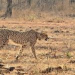
Driving to Mig La Pass is a real adventure. There is no phone signal or repair shop along the route. Loose gravel, steep bends, and thin air make the drive challenging. The landscape is just as impressive as the drive. Vast mountains, open plains, and dry valleys stretch across the horizon under a deep blue sky. In some places, rust-colored hills contrast with bright patches of snow and ice, creating beautiful views. The silence of the region adds to its wild and untouched feel. Despite the harsh conditions, wildlife survives here. Travelers often spot Kiang, the Tibetan wild ass, roaming the plains in small herds. Himalayan marmots are also common and can be seen near their burrows along the roadside.
Seeing soldiers serve in such extreme conditions gives you a deep sense of respect. Their presence highlights the importance of this remote area. By the end of the journey, you feel both humbled and grateful. The combination of a challenging drive, stunning landscapes, unique wildlife, and the dedication of the soldiers makes Mig La Pass an unforgettable experience.
What You Can Do at Mig La Pass
The main highlight of visiting Mig La Pass is the challenge of reaching the summit itself. Because the road is unpaved and sits at a massive 19,400 feet, the drive or motorcycle ride requires total focus. At the top, the air is incredibly thin, so you can only stay for about ten minutes. During this short stop, you can take photos by the summit marker and look out over the vast, empty mountains of the Changthang plateau. The absolute silence at the peak makes the environment feel both extreme and peaceful.
Beyond the pass, the surrounding region offers a rare look at remote Himalayan life. You can visit Hanle, a quiet valley famous for its historic hilltop monastery and exceptionally clear night skies, which make it India’s top spot for stargazing. The entire driving route sits inside a wildlife sanctuary, allowing you to watch wild Kiang, marmots, and rare birds in their natural habitat. You will also pass through Hanle and Fukche, tiny border villages that give you a sense of just how isolated this frontier really is.
Permits Required to Visit Mig La Pass
To visit Mig La Pass in Ladakh, you need an Inner Line Permit (ILP) from the Leh district administration. This permit is required for travel in the Changthang region, including routes that pass through areas like Hanle and nearby remote villages. You can apply for it online or in Leh before starting your journey. The permit is checked at several army and police checkpoints along the way, so you must carry printed copies along with a valid ID.
Travel rules can change depending on security conditions because this is a sensitive border area near the Line of Actual Control. Some parts may have extra restrictions, especially for foreign travelers. Basic government fees for environment and wildlife protection are also added during the permit process. Overall, proper permits are important because without them, you cannot legally travel toward Mig La Pass or its connecting routes.
Where to Stay
Accommodation near Mig La Pass is very basic because the region is remote and sparsely populated. Most travelers stay in homestays in nearby villages such as Hanle before continuing their journey. These homestays usually provide simple rooms, local meals, and a comfortable place to rest. It is a good idea to book in advance during the travel season, as options are limited.
Essential Things to Carry
Travel to Mig La Pass requires careful preparation. An Inner Line Permit from Leh is required, and you should carry printed copies along with a valid ID. Fuel planning is important because petrol stations are far apart, so extra fuel may be needed. A basic medical kit, medicines for altitude sickness, warm clothing, gloves, and windproof layers are highly recommended. You should also carry enough water, snacks, and basic emergency tools, as there are long stretches with few services. Proper planning and the right supplies will make the journey safer and more comfortable.
Conclusion
Reaching the summit of Mig La Pass is much more than a box to check on a road trip. The extreme 19,400-foot altitude, the unpaved border tracks, and the harsh isolation of the Changthang plateau make this one of the most demanding drives in the Himalayas. It forces you to plan carefully, respect the mountain weather, and rely entirely on your own preparation.
When you finally stand at the peak looking out over the empty border landscape, the immense silence stays with you. It is a journey that tests your limits and gives you a deep appreciation for the resilient local communities and military personnel who live on India’s highest frontier. Long after you return home, the memory of that thin air and raw landscape will change how you look at adventure travel.